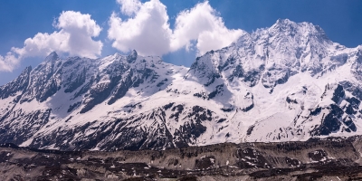
Tsum Valley Trek, offered by Plan Nepal Trek & Expedition, takes you on a journey through one of Nepal’s most remote and untouched Himalayan regions. Nestled in the mid-north-west Himalayas of the Gorkha area, the Tsum Valley is a hidden gem also called the “Valley of Happiness.” This trek ventures into secluded, rarely visited villages that have preserved their ancient Tibetan culture, surrounded by majestic peaks of the Manaslu and Ganesh Himal mountain ranges. Unlike the more popular trekking routes in Nepal, Tsum Valley offers an authentic glimpse into the serene wilderness and spiritual lifestyle of its inhabitants, making it a truly special and immersive adventure.
The name “Tsum” originates from the ancient Tibetan word “Beyul Kyamlung,” meaning the “Valley of Great Happiness.” This mystical place holds great spiritual significance with many sacred monasteries and pilgrimage sites scattered throughout the region. Trekking here is not only a physical challenge but a chance to experience the rich traditions and warm hospitality of the local people, who are believed to be direct descendants of Tibetan immigrants. The trek offers stunning panoramic views of snow-capped mountains and pristine landscapes, making every step a rewarding experience.
Best Time for Tsum Valley Trek
The ideal seasons to embark on the Tsum Valley Trek are during the autumn months from late September to November and the spring months from March to May. These periods offer the most stable weather with clear skies and moderate temperatures, perfect for trekking and mountain views. During autumn, the rhododendron forests and alpine meadows burst into vibrant colors, enhancing the natural beauty of the trail. Springtime, on the other hand, is famous for its blooming wildflowers and lush green landscapes.
Winter months from December to February can be extremely cold, especially at higher altitudes, and heavy snowfall might block the trails. Similarly, the monsoon season from June to early September is not recommended as frequent rain can cause landslides, slippery trails, and limited visibility of the mountains. Planning your trek with Plan Nepal Trek & Expedition during the prime seasons ensures a safe, enjoyable, and visually spectacular experience.
Tsum Valley Trekking Difficulty
The Tsum Valley Trek is categorized as a moderate to challenging trek. While it does not involve technical climbing or extreme altitudes, trekkers should be prepared for long walking days on rugged trails, some steep ascents and descents, and an average altitude of 3,000 to 4,500 meters. The terrain varies from lush forests to rocky mountain paths, requiring good physical fitness and stamina.
Trekking through remote and isolated villages means limited access to modern conveniences, so mental endurance and a spirit of adventure are essential. However, the trek does not require advanced mountaineering skills, making it accessible to enthusiastic hikers who have some prior trekking experience. Plan Nepal Trek & Expedition provides expert guides and support staff to assist with acclimatization and ensure your safety throughout the journey.
Food and Accommodation for Tsum Valley Trek
Food and accommodation options during the Tsum Valley Trek are simple but comfortable, reflecting the rustic charm of this remote Himalayan region. Most nights are spent in traditional teahouses or lodges, which provide basic amenities such as clean bedding and hot showers where available. The hospitality of the local people adds warmth to the trek, as many lodges are family-run and offer delicious home-cooked meals.
The menu mainly consists of Tibetan and Nepali dishes such as dal bhat (rice with lentils), momos (dumplings), noodles, soups, and fresh vegetables. Drinking water is usually available, but it’s recommended to purify or drink bottled water to avoid any stomach issues. As the region is remote, it is wise to bring some snacks and energy bars. Plan Nepal Trek & Expedition ensures trekkers have access to safe and nutritious food and comfortable lodging, making your stay pleasant after long days on the trail.
Why Choose Tsum Valley Trek with Plan Nepal Trek & Expedition?
Choosing Plan Nepal Trek & Expedition for your Tsum Valley adventure guarantees a well-organized, authentic, and safe trekking experience. With years of expertise in Nepal’s trekking industry, the company is committed to providing personalized service, knowledgeable guides, and logistical support to ensure a smooth journey from Kathmandu to the hidden valleys of Tsum. They prioritize responsible tourism by respecting local culture and supporting sustainable travel practices that benefit the communities.
Their detailed itinerary balances adventure and cultural exploration, allowing trekkers to immerse themselves in the unique environment without feeling rushed. The company also emphasizes safety, offering thorough briefings, acclimatization days, and reliable equipment. For anyone looking to discover a lesser-known part of the Himalayas with the backing of an experienced and trustworthy operator, Plan Nepal Trek & Expedition is the perfect choice.
USEFUL TIPS IN SAVING ENERGY
After landing in Kathmandu at Tribhuvan International Airport. Our delegates will be present there to receive you with warm greetings and then guide you to your respective hotel in a private vehicle.


The activity of the day begins with a sightseeing trip. Our city guide will take you to several fascinating world heritage sights, allowing you to learn about the cultural practices of the lives of ancient Kathmandu locals that were practiced for many generations back.
Also known as a living museum, the city of Kathmandu has a lot to offer visitors. It has many ancient monuments and artifacts dating back hundreds of years that have cultural and architectural imprints amalgamated together, belonging to different eras that have been beautifully fused over time to this present day. One of them is the Kathmandu Durbar Square site, which is usually jam-packed with the hustle and bustle of the locals and visitors from different nooks and crannies around the world.
After the sight at Durbar Square, we head for our next site, the stupa of Swayambhunath( a stupa popularly also known as a monkey temple due to the fact that monkeys are abundantly hanging around in the sites).
Since the Kathmandu Valley is loaded with natural heritage sites even within its small radius, we'll be heading for our next site to visit, which is Bouddhanath Stupa.
After doing the sightseeing of various monuments, we'll take a break to have lunch at a local restaurant and continue our trip to head towards the Pashupatinath Temple. Located on the eastern side of the valley, it is one of the religious sites that holds significant religious and cultural importance for all Hindus around the globe.
The trip and the activity for the day are completed, and we get back to our place to have dinner. We'll be preparing for our trek the next day.
Todaywe'll head for the trip to Machhakhola. The trek starts with a crossing ofSoti-Khola, where you'll get to visualize magnificent views of multiplewaterfalls and rivulets. Next, you'll be taking a walk across a beautiful sal forest full of greenery and serenity that nature has to provide, after whichyou'll get to a ridge above the massive Budhi-Gandaki waves, and you'll carryon with your trip to Liding and reach Khursane.
Followingthe sandy edges of the Budhi-Gandaki River, the river exits Khursane anddescends by the side of hillside farmlands to the ethnic hamlet of Lapubensi.After that, the trails go through a broad valley and lead to Nauli Khola, whichyou'll have to go across to get to Machha-Khola. The trip for the day concludeshere, after which you'll be served dinner at the local lodge with accommodationfor the night.
On this day of the trip, we'll be heading for our destination of the day which is Chhokapangro. The trip starts as the sun rays hit land in the morning. The upper Tsum Valley emerges from the plains of Chhokang Paro, which is not just one but two different places. one of them is chhokang and paro and the other is paro. ideally, you'll be proceeding alongside the river route of the Shair-Khola to Dumje following the route ahead you'll be ascending to get to the Chhokangparo where you'll get to witness the breathtaking views of Ganesh Himal and Himalchuli along with the best hospitality of the natives.
To get to Nile, which'll be our next destination, which is situated on the western side of the Shiar Khola, we'll have to hike for approximately 25 minutes from Nile to Chhule. We'll also go across the holy dungeon called Piren-phu, a cave with an abundant presence of piegon, according to the famous legend of the Tibetian Buddhist Master Milarepa, who is said to have meditated and left his traces of footsteps. You'll be going across two more gumbas that represent the beautiful artwork of Buddhism. In these gumbas, there are well-crafted scripts inscribed on paper documents that elevate their status as social and cultural assets. To get to the nile village, we'll cross the shair khola.
We'll be continuing downhill from Chhokangparo to Gho, where we'll be crossing the suspension bridge, and then hiking to Rainjam village, from where we'll drop down further to Tsum Valley and ultimately arrive at Chumling, which will be our destination for the day, where we'll be unwinding, have dinner, and prepare for the day ahead.
We'll be departing from Chumling and continuing to get downhill, so the trip for today will be easier in comparison to others. We'll be heading along the edge of the river Shair-khola to get to Lokpa village. If the day of our arrival on Lokpa is a pleasant one, then we might be lucky enough to come across a herd of animals along the trail. The trail, after passing through the lokpa, descends as we cross through the Budi-Gandaki river on a concrete bridge that goes through the narrow gorge from where it ascends and descends while we're gradually getting uphill through the valley. We'll be crossing a river on a suspension bridge to Nupri and then passing through bamboo forests to get to the settlement, with the majority of residences inhabited by Gurung communities.
We leave Namrung behind and get across the numerous Mani Wall entrance gate, a few Buddhist gompas, and a few villages before the valley opens up and our route passes via Sho village, which has lots of yaks and offers great views of both Manaslu and Manaslu north.
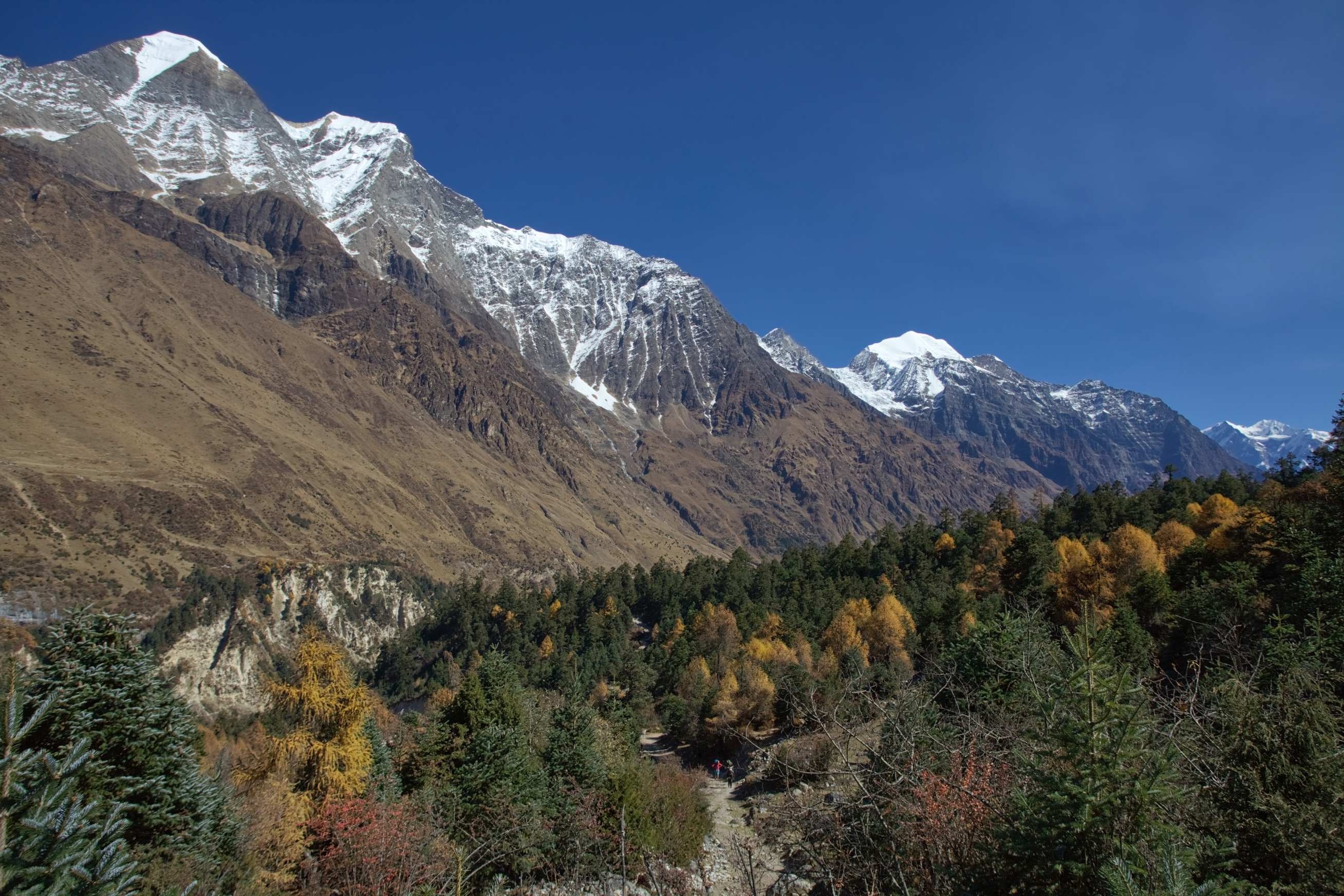
After a few hours of ascending through the forest, we'll get to Shyala village, from where we can witness the beautiful mountain peaks like Himalchuli, Manaslu, and Phungi. this will be a great day to enjoy the views of the peaks.
As we keep moving forward, the Ganesh Himal and himal-chuli will be very visible. At the far end of Sama-Gaon is a well-known monastery. The Tibetian border is very near here. We'll end the tip for the day at Samagaon and unwind to acclimatize.
In order to continue our trip ahead, we must be properly acclimatized to every altitude we're at. So just like that, we'll also acclimatize and use our time wisely in order to adapt to our surroundings. This village is situated very close to the Manaslu basecamp to ensure adequate acclimatization. The settlement has thousands of Mani stones with Buddhist texts and sculptures on them, and the local women put on beautiful silver spoons as a piece of jewelry. This day is segregated as a day for unwinding, but if you're energetic and active enough to involve yourself in additional activities, you can choose to go to places like snowy valleys and have a glance at the Pungyen Gompa or take a look at the fantastic views of the lake Birendra. Alternatives are also present, like if you just want to explore the Samagaon and chill, you can simply visit the Pungyen monastery that is underneath the face of Mount Manaslu.
We'll be starting our trip tomorrow morning from Sama Gaon and heading to Samdo on a hike that'll take us across the Budhi Gandaki Wooden Bridge and gradually up to the Samdo Valley. During this trip, we'll cross through terraced fields of cultivated land next to old Mani walls. We cross the wooden bridge over the river Budhi-Gandaki and ascend gradually to the Samdo valley. The ascent to the larky la pass starts at another mani wall. We cross two streams and see the Larkya glacier. Next, we go around the Salka Khola valley, ascend, and arrive at the stone guest house, also known as Dharmasala, or Larky la phedi. Here you can witness the beautiful views of Manaslu Mountain and Larkya Glacier. We'll rest at Larkya La Phedi and get ready to cross the Larkya La Pass.
We'll be moving ahead from Dharmasala and will be hiking along the longest and toughest section of the trek. We need to get across the Larky La Pass, as this region is notorious for its strong winds. The route begins with an easy ascent that goes through the ridge. it gets slightly downwards to the lake and becomes rough and indifferent as it crosses the slopes of grassy land and then gets ragged and hazy.
The trail follows the top of moraine to the west and makes a series of steep, rough switchbacks when it goes across the moraine and then descends more gently on loose gravel to another lush green moraine following which the terrain of the trail gets easier to navigate. The valley then becomes broader as the trail heads down to large meadow, past a mani wall and a residence small enough to wind-down house that represents the place Bhimtang moving forward from where we'll descend down to four frozen lakes and make the final ascent to the pass from where we get across and also get to enjoy the stunning views of the snow-capped mountains.
The trailhead is at Bhimtang. From there, it crosses a moraine, descends to the Dudhkhola water source, crosses a wooden bridge, and then heads into pine and rhododendron woods to reach Hompuk. The forest provides antural shelter to a wide range of animals, such as sheep, horses, and monkeys, and you can enjoy the panoramic views of Phungi, Manaslu, Manaslu North Peak, Cheo Himal, and Himlung Himal.
After a 30-minute descent through the woods, the destination known as Sangore-Kharka arrives from there onward. We'll be moving across a landslide and climbing steadily to a ridge decorated with chortens, from where the trail descends to the riverbank at Gho.
On this day of the trip, the path winds up and down, mostly going across the fields but also through the dense forests at specific moments and events. It takes less than an hour to get to Tilije, which is a multi-ethnic settlement with thorny fields and sporadic rhododendron and oak woods. After leaving Tilije through a stone arch, we'll cross the Dudh-khola and follow its embankment that descends through the scrub forest. The walls of the Marshyangdi River will keep appearing larger with every rotation of the wheels, and as time moves forward, the residence of Dharapani starts to appear in the distance passed forward. We'll also go across the Thonje village, crossing a wooden bridge. We'll be crossing the Marshyangdi River by going on a suspension bridge, and moving forward, we'll continue to walk to Tal, where we'll be served dinner and accommodated with lodging service to stay overnight.
we'll be on the road on a ride from Tal to Besisahar, and the trip takes around 4–5 hours. While on the road, we'll get to witness several residences in Bhulbhule and Khudi-Besisahar. There are not many vehicles around the corner in the areas, so we must be punctual in order to get a ride on time. At least by 3 p.m., everyone should be at the station since it would be the last opportunity to get on the ride to Kathmandu, and on the backside, the road along the trip has a great view and picturesque natural beauties for you to witness. On the way, the Marshyangdi River meets the Trihuli River as we head towards the eastern side of the Pritivi Highway.
Today is the last day of our trip here in Nepal. After a healthy breakfast, our delegate will drive you to the airport in your private ride and then drop you off at the airport.
It was a beautiful trip through the majestic Himalayan nation. Full of thrilling experiences. I absolutely loved the company on the trip and the communicative nature of the staff. Nepalese hospitality is unmatchable.
Clothing
Handwear
Footwear
Gear
Miscellaneous
The time spent trekking each day depends largely on your walking pace and fitness level. However, for most travelers, it’s recommended to walk at least 3 hours daily on average. This pace allows you to enjoy the breathtaking scenery, acclimatize properly, and explore the local culture without rushing. Some days may require longer trekking hours depending on the distance between villages, while rest days are included to help with altitude adjustment and recovery.
Tsum Valley is located within a restricted and protected region, so trekkers must obtain several permits before starting the trek. These include the Manaslu Conservation Area Permit (MCAP), which allows access to the conservation zone, the Tsum Valley Restricted Area Permit specifically for the valley itself, and the Tourist Information Management System (TIMS) card, which is mandatory for all foreign trekkers in Nepal. These permits help regulate tourism and protect the fragile environment and local culture.
Visitors should strive to minimize their impact on the pristine natural environment. Avoid disturbing wildlife habitats by not playing loud music or engaging in activities that could disrupt animals or plants. Respect local customs and traditions by dressing modestly and behaving politely. It’s also advised to avoid littering and to carry out all trash. Maintaining a quiet, respectful presence helps preserve the valley’s tranquility and the spiritual atmosphere cherished by the locals.
The ideal seasons for trekking in Tsum Valley are autumn (late September to November) and spring (March to May). During these times, the weather is typically clear and pleasant, offering stunning views of the snow-capped peaks. Autumn presents crisp air and colorful forests, while spring dazzles visitors with blooming rhododendrons and fresh greenery. Monsoon and winter seasons are generally less favorable due to heavy rain, landslides, and cold temperatures.
Tea-houses along the trek provide basic but comfortable accommodations where trekkers can rest and enjoy warm meals. Most lodges are family-run and maintain a peaceful environment, so it’s important to avoid loud noises like music or shouting to respect other guests and the local residents. The facilities might be simple, with shared bathrooms and limited hot water, but the hospitality is warm and welcoming, offering a genuine cultural experience.
Drinking water can be sourced from local streams and lodges, but it is essential to purify it before consumption. Boiling water is the safest method to avoid waterborne illnesses, though many lodges also sell bottled mineral water at reasonable prices. Trekkers should carry water purification tablets or filters as a precaution. Staying hydrated is critical in high-altitude trekking, so plan accordingly and ensure access to safe drinking water throughout the journey.
On average, trekkers should budget around $30–$50 per day to cover accommodation, three meals, and other basic expenses if organizing the trek independently. If you book your trek through a company like Plan Nepal Trek & Expedition, the package usually includes lodging, meals, guides, and permits, which can make budgeting more predictable. Additional personal expenses such as snacks, hot showers, Wi-Fi, and drinks should be factored into your budget as well.
For non-Nepalese citizens, trekking in Tsum Valley without a guide is not permitted due to the region’s restricted status. Foreign nationals must have a TIMS card and a restricted Area Permit, both of which require being accompanied by a licensed guide. Additionally, trekking parties must include at least two people and one guide for safety and regulatory reasons. This policy helps ensure the safety of visitors and supports the conservation of the region’s delicate ecosystem and culture.