Need help with booking? Send us a message.
The Annapurna Circuit with Tilicho Lake Trek is one of the most captivating and challenging treks in Nepal, offering a once-in-a-lifetime journey through some of the world’s most dramatic landscapes. Organized by Plan Nepal Trek & Expedition, this trek beautifully combines the cultural richness of the Himalayan region with an adventurous trail that loops around the Annapurna Massif. The trek traverses subtropical forests, alpine meadows, and high-altitude passes, reaching as high as Thorong La Pass at 5,416 meters, the trek's highest point. You'll follow the Marsyangdi River valley before crossing into the Kali Gandaki valley, which forms the world’s deepest gorge between Dhaulagiri and Annapurna I.
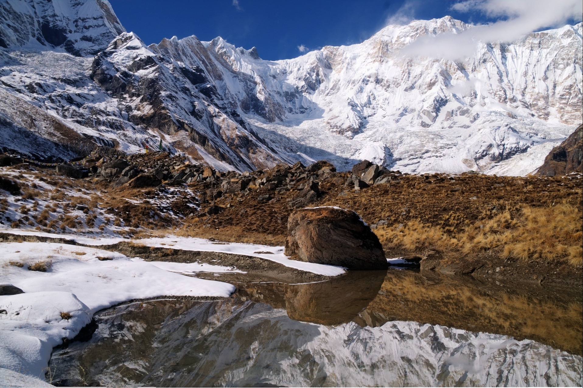
A special highlight of this route is the detour to Tilicho Lake, the highest lake in the world at 4,919 meters. This isolated, sapphire-blue glacial lake is surrounded by towering peaks and is both spiritually and visually captivating. The trail also provides a cultural deep dive into the lives of the Gurung, Thakali, and Tibetan-influenced communities, showcasing authentic village life, Buddhist monasteries, prayer flags, and Himalayan hospitality. This itinerary spans 22 days and is designed for trekkers who want both the thrill of a high-altitude trek and a cultural adventure that goes beyond the ordinary.
Best Time for Annapurna Circuit with Tilicho Lake Trek
The ideal seasons for the Annapurna Circuit with Tilicho Lake Trek are spring (March to May) and autumn (mid-September to November). During spring, rhododendron forests bloom in vivid colors, temperatures are moderate, and visibility is excellent for panoramic mountain views. This season also allows for easier passage through high altitudes as the snow begins to melt, particularly around Tilicho Lake and Thorong La Pass.
In the autumn season, the skies are generally clear with crisp air, offering stunning visibility of the Himalayas. This post-monsoon period means the trails are dry and ideal for trekking. Winter (December–February) is possible for experienced trekkers but expect heavy snow and freezing conditions. Monsoon (June–August) is least recommended due to landslides, leeches, and slippery trails.
Annapurna Circuit with Tilicho Lake Trekking Difficulty
The Annapurna Circuit with Tilicho Lake Trek is categorized as a moderate to strenuous trek, primarily due to the high-altitude terrain and the length of the itinerary. The inclusion of Tilicho Lake makes the route slightly more demanding than the standard Annapurna Circuit. Trekkers should be prepared to walk 6–8 hours per day on rugged trails, with significant ascents and descents.
Acute Mountain Sickness (AMS) is a serious consideration due to the high altitude. Fortunately, the itinerary includes a proper acclimatization day at Manang, which helps the body adjust to the elevation. A good level of physical fitness and mental resilience is important. Prior multi-day trekking experience is helpful, but not mandatory if you train beforehand and go with an experienced guide from Plan Nepal Trek & Expedition.
Food and Accommodation During the Trek
Throughout the trek, accommodation is provided in local teahouses, which offer basic yet comfortable lodging. Teahouses typically include a twin bed, mattress, pillow, and blanket. While heating may not be available in rooms, dining areas often have a wood stove or heater to warm you up during dinner. At higher elevations, facilities can be more basic, but the hospitality remains warm and welcoming.
As for food, trekkers will be served nutritious and hearty meals three times a day. Typical meals include dal bhat (rice, lentils, vegetables), noodles, pasta, Tibetan bread, eggs, soups, and porridge. Hot beverages like tea, coffee, and ginger lemon honey tea are widely available. As you ascend higher, food variety may reduce slightly due to limited transportation, but Plan Nepal Trek & Expedition ensures quality food and safe water for every trekker.
Why Choose Annapurna Circuit with Tilicho Lake Trek
This trek stands out because it goes beyond the popular Annapurna Circuit by incorporating the majestic Tilicho Lake, making it a true adventure for nature lovers and cultural explorers alike. It offers a 360-degree Himalayan experience—ranging from lush valleys and terraced farmlands to barren alpine deserts and snowy passes. The route showcases a vast array of flora and fauna and lets you walk through traditional villages where you can interact with ethnic groups like Gurungs, Thakalis, and Manangis, gaining firsthand insight into Himalayan traditions and lifestyle.
Moreover, trekking with Plan Nepal Trek & Expedition ensures your safety, comfort, and local insight. With well-designed itineraries, experienced guides, porter support, and attention to acclimatization and health, the company is dedicated to delivering a memorable and safe Himalayan experience. Whether you’re a solo traveler or part of a group, this trek is a perfect blend of physical challenge and spiritual reward.
Things to Know Before Traveling
Before exploring on this trek, it’s essential to respect local customs and etiquette. Photography is restricted around military and religious sites, and always ask permission before taking photos of locals. Pointing at people or religious objects with your finger is considered impolite; instead, use your whole hand or nod.
Dress modestly, especially in villages and monasteries. Avoid wearing revealing clothes, and be mindful of local traditions. Trekking in the Himalayas also means unpredictable weather, so pack according to the season, including layers, rain gear, sunscreen, and altitude medication. Importantly, stick to the itinerary and instructions provided by Plan Nepal Trek & Expedition, especially when dealing with altitude and route changes for safety.
TIPS FOR SAVING ENERGY WHILE TRAVELING.
It's very essential to be in touch with friends' families and colleagues during the trip to provide frequent updates on travel. To do so, the supply of energy to charge the devices to do the web access is very much required, which is very much necessary to save energy.
Following are some tips to save energy:
For the camera, get some spare batteries.
 Accommodation 3 star Hotel
  Meals Breakfast, Lunch, and Dinner
  Max. altitude 1,400m / 4,593ft.
 The trip starts with the drive from Kathmandu-Pokhara. highway to Bulule, then a rough path alongside the river Marshyangdi. After 6 hours of traveling by bus, we'll arrive in Besisahar, Lamjung District's capital. The drive to Bulbule begins and after reaching there we'll be served dinner and stay overnight.
Accommodation lodge Meals Lunch and dinner Max. altitude 0m / 0ft. Today we'll be walking past the villages down the road and to the edge of Marshyangdi River. We'll keep heading upwards for about 5–6 hours to reach our last destination for that day, the Brahmin village of Bahundanda, where we'll spend the night and eat dinner at the lodge.
Accommodation lodge Meals lunch and dinner Max. altitude 0m / 0ft. From Bahundanda, the trek path descends to Syange and crosses the Marshyangdi River on a suspension bridge. It then climbs sharply and crosses the cliff face to the stone settlement of Jagat, where you'll have lunch. Today's walk should take around 4-5 hours. The path then declines before ascending through the junction to Chamje. Dinner and an overnight stay at the lodge are to follow.
Accommodation lodge Meals lunch and dinner Max. altitude 0m / 0ft. On this day we'll begin our trip ahead, which we'll do by crossing the suspension bridge over the right bank of the Marshyangdi River. After hiking to Tal, noted for its valley, views, and waterfalls, we'll reach the Manang district. After passing Khotro, the road keeps going through the fields of barley, rice, and potato farms, as well as pine forests. The new route continues through the settlements of Kare and Nache, with a ceremonial entrance to Dharapani provided by stone kani. At the lodge, you'll be served dinner and spend the night.
Accommodation lodge Meals Lunch and dinner Max. altitude 0m / 0ft. we'll head for Chame, the administrative center of the Manang district. From Chame, we'll climb the slope to Bagarchhap, passing through the forest of blue pine, spruce, hemlock, maple, and oak trees. when we proceed through the woods to Danaque, a valley lined with apple trees. The trail ascends the mule road into the larger oak and maple trees. Dinner will be served at the lodge where we'll be spending the night.
Accommodation lodge Meals Lunch and dinner Max. altitude 0m / 0ft. Accommodation lodge Meals Lunch and dinner Max. altitude 0m / 0ft. Soon after breakfast, the road takes a left turn into a charming village painted by mandalas. then we hike across grazing pastures and a variety of crops. The path to Ngawal climbs a tough slope on the right bank of the Marshyangdi River Valley. Along the way, we'll come across a pine forest, an agricultural terrace, and large Tibetan settlements that offer spectacular views of Mt. Annapurna and Gangapurna. Dinner and overnight stays will be facilitated at the lodge.
Accommodation Lodge Meals Lunch and dinner Max. altitude 0m / 0ft. Accommodation lodge Meals Lunch and dinner Max. altitude 0m / 0ft. Post-breakfast, you'll be hiking up an ascent track and crossing the suspension bridge over the Manang River on the way to Shri-Kharka. You'll ascend a pine-forested path that leads to Khangsar village, which is surrounded by a snow-capped peak from all directions. From Khangsar, you'll continue on a steep track to Shri-Kharka. The trip for the day concludes with dinner for the night and a stay at the lodge.
Accommodation lodge Meals Lunch and dinner Max. altitude 0m / 0ft. Today we'll be heading for the Tilicho basecamp after breakfast. Since you're only going to be climbing for a short distance, today's walk will not be as strenuous. However, you should take caution as the path passes through areas where landslides can occur. On the way, you'll pass by impressive rock structures. Once you reach the base camp, you'll get to enjoy the stunning views of the mountains that surround you. Dinners will be served at the lodge, where you'll be served dinner and spend the night.
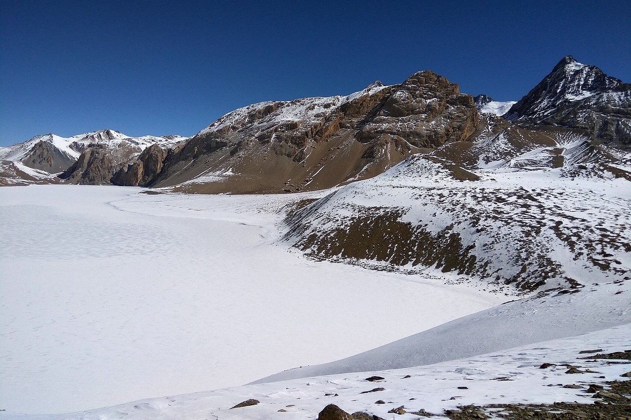
Accommodation Lodge Meals Lunch and dinner Max. altitude 0m / 0ft. The most important day of our trip starts now. We'll climb to Tilicho base camp after breakfast, as the wind might disrupt us if we're late. The Tilicho Trail starts in a side valley and ascends a moraine. From there, you may see Tarkeghyang, Gangapurna, and Khangsar Kang. The world's tallest lake, Tilicho, offers a stunning view with its turquoise water and occasionally reflects the peak, but it is usually frozen solid. After spending some time at Tilicho Lake, we'll return via the same route. After spending some time there, we'll walk for 8–9 hours. during which you'll be served dinner and spend the night at the lodge.
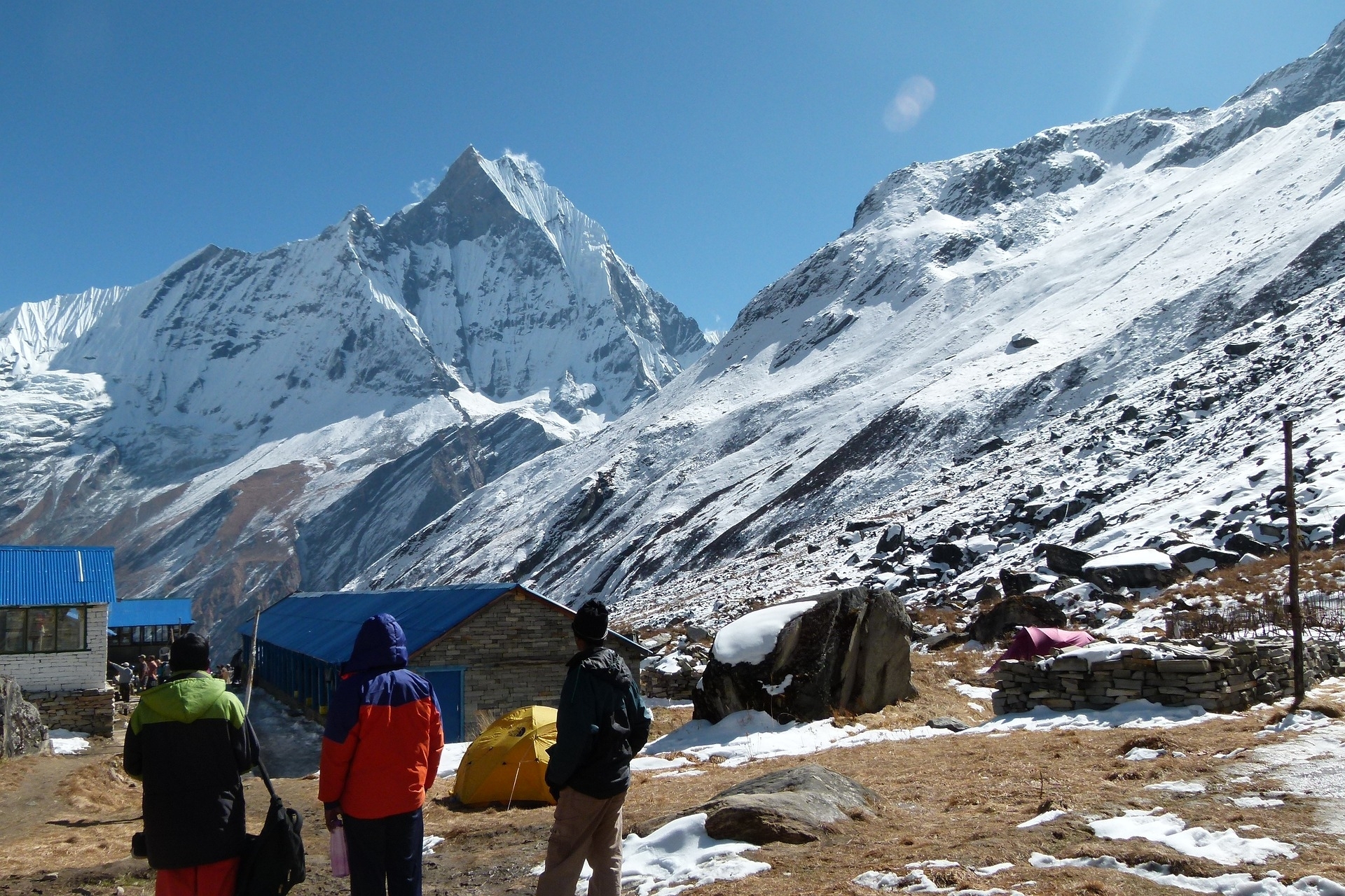
Accommodation lodge Meals Lunch and dinner Max. altitude 0m / 0ft. We'll ascend gradually to the summit of a hill, then descend to the mainstream of the Marsyangdi River and crossover on a covered wooden bridge. We then briefly ascend along the road on the right bank, take a shortcut across the unstable high slopes, and descend to the Thorung La high camp. Before climbing the Thorung La Pass, that'll be the final camp. At the lodge, you'll be served dinner and provided with an overnight stay.
Accommodation lodge Meals Lunch and dinner Max. altitude 0m / 0ft. Today we'll have to rise early to traverse the beautiful Thorung La Pass. But the start of the trip route is going to be steep as soon as we leave the camp to go ahead. but even if it's steep, the trail is well-marked, as people have been on the route using it for several years. Eventually, the slopes ease, and after nearly 4 hours of ascent, we reach the prayer flags at the pass. The views are amazing, ranging from the snowcapped mountains above to the head of the Kaligandaki River below., to the brown and purple hills of the Mustang that stretch out before us. The descent to the Muktinath is difficult, but the beautiful views of Mt. Dhaulagiri offer a welcome diversion. The night will be spent at the lodge after dinner.
Accommodation Lodge Meals Lunch and Dinner Max. altitude 0m / 0ft. Today we'll be heading out of Muktinath to Jomsom, starting the trip with an amazing descent through the valley of Kali-Gandaki, through the dry land in the same geological and climatic zone as Tibet. We'll pass through the traditional Tibetan villages of Kharkot and Khingar, and then follow the valley floor for the majority of the journey, enjoying good views of both Dhaulagiri and Nilgiri mountains. Jomsom is a sprawling town that runs parallel to the Kali-Gandaki River on both sides. You'll have dinner and spend the night at the lodge.
Accommodation Lodge Meals Lunch and dinner Max. altitude 0m / 0ft. Today we'll depart Jomsom for Kalopani, walk for 7-8 hours, and have lunch at Marpha. We'll then cross the river and walk to Chokhepani, passing through the Tibetian refugee camp in Chairo. The trip from Tukuche is sloping; we'll pass through the small villages of Sauru, Kobang, and Larjung. After crossing the river, we'll continue down to Kalopani. After dinner, the overnight stay will be at the lodge.
Accommodation lodge Meals Lunch and dinner Max. altitude 0m / 0ft. Today we'll leave Kalopani and head to Tatopani, which means ''hot water'' in English translation, where we can use the two hot springs before the walk is over to give as much as needed breaks to our legs. The dinner will be served at the lodge, where the overnight will be spent. Today we'll be approaching one of the major highways, so we can divert the main path and follow the river until we reach Ghasa. Most of the day will be spent descending, including crossing a river just before Tatopani.
Accommodation lodge Meals Lunch and Dinner Max. altitude 0m / 0ft. On this day, we'll set out for our trip to Ghorepani, working our way through the woods until we reach Shikha. The trail will take us approximately 7-8 hours. From the altitude we're at, the wonderful views of the Dhaulagiri mountain can be seen, along with the Kali-Gandaki valley. We'll then continue through the rhododendron forest to Ghorepani, where we'll have dinner and spend the night at the lodge.
Accommodation lodge Meals Lunch and Dinner Max. altitude 0m / 0ft. Today we'll wake up early and make it to Poonhill before dawn. We'll also climb to Poonhill, which is the highest panoramic viewpoint in the Annapurna Region and offers a stunning view of the rising sun and its rays cascading over the Annapurna and Dhaulagiri hills. After you've taken the shot, head back to the Ghorepani for delicious morning tea. This hike is strenuous, with beautiful scenery along the way. Your jeep will be waiting for you to get to the Hile, and you'll be driven for 3–4 hours to Pokhara, where you can check into your hotel, go for a stroll around Lakesides, or go for a trail run. At the hotel, we'll have dinner and stay overnight.
Accommodation hotel Meals Lunch and dinner Max. altitude 0m / 0ft. After breakfast, you can go paragliding or sightseeing in Pokhara. Then you can enjoy a complementary meal before taking a 30-minute flight to Kathmandu, where you will be met and helped through the check-in process. After a while, you can go for a stroll around Thamel and go shopping. The flight includes dinner and a bed at the hotel.
Accommodation hotel Meals breakfast, Lunch and dinner Max. altitude 0m / 0ft. On this final day of your trip, breakfast will be served for you at the Bouddhanath. We'll take Stroll through the Kathmandu Valley, see Durbar Squares, or go shopping, and then meet your guide for a farewell lunch later that evening.
Accommodation 3 star hotel Meals breakfast, farewell lunch Max. altitude 1,400m / 4,593ft. The 22-day trip finally comes to an end. Today will be your last day in Kathmandu. After a healthy breakfast, our delegate will have a few brief conversations about the trip before driving you to the airport on your private ride three hours before your flight.
Meals Breakfast Max. altitude 1,400m / 4,593ft.
Your Start Date is the day you land in Nepal, and your End Date is when you fly home.
If the set Annapurna circuit with Tilicho lake trek group dates don’t suit your schedule, we can offer alternative dates upon request.
Proper layering is important to stay warm and comfortable in changing mountain weather.
Good footwear makes trekking easier and safer.
The right gear keeps you safe, comfortable, and prepared.
Lightweight but important items keep you clean, healthy, and comfortable.
Keep important items safe and easy to reach.
One of the best destinations ever visited in a lifetime. The team and its members were very cooperative and gracious. Thank you for the service
I've got to be honest from my heart. The trip was a unique blend of highlands and lower levels. The serenity of Nepal is rarely matched with any other place in the world and makes a visitor feel like heaven on earth. A traveler must consider giving s shot at visit to Nepal
I have no words to describe the trip and the beauty of the place. I visited one of the lakes at the highest altitude, the vicinity was so calm and refreshing that would clear any mind and give peace, overall I loved the trip and was one of the best trip of my life.
The daily trekking duration on the Annapurna Circuit with Tilicho Lake trek largely depends on your personal pace and physical condition. On average, trekkers walk between 5 to 7 hours per day, depending on the terrain and altitude gain. In the lower elevations, the walk may be shorter and easier, but as you ascend, especially past Manang and towards Thorong La Pass, the pace generally slows to allow proper acclimatization. Plan Nepal Trek & Expedition ensures that the itinerary is designed to balance both challenge and comfort, with plenty of breaks, scenic stopovers, and time to enjoy the journey at your own pace.
While trekking through the Annapurna region, it's important to respect both the environment and the local culture. Avoid playing loud music, shouting, or causing disturbances, as these can disrupt wildlife and the tranquil nature of the trail. Alcohol and recreational drugs should be avoided, especially at high altitudes, where they can worsen symptoms of altitude sickness. Always ask permission before taking photos of people or religious sites, and avoid pointing at people or objects with your fingers—use your whole hand instead. Also, stay on designated paths to protect the fragile ecosystem and avoid getting lost or injured.
If you're looking for a truly transformative Himalayan trekking experience, the Annapurna Circuit with Tilicho Lake trek is highly recommended. Though physically and mentally demanding, this trek rewards you with breathtaking landscapes, cultural richness, and spiritual energy that few other trails can offer. You’ll traverse diverse terrains—from green valleys and cascading waterfalls to alpine deserts and high mountain passes. With proper preparation, a moderate level of fitness, and the expert guidance of Plan Nepal Trek & Expedition, anyone with a strong sense of adventure and determination can complete this journey and return with unforgettable memories.
Mobile network coverage is available in most villages along the route, but the signal can be unreliable or weak at higher elevations. Wi-Fi is available in many teahouses for a fee, although the speed is often slow, especially above Manang. If you need consistent connectivity, it’s advisable to buy a local SIM card (NTC or Ncell) in Kathmandu before your trek begins. That said, the trek is an excellent opportunity to disconnect and immerse yourself in the mountains, using the limited connectivity to stay focused on the experience and natural surroundings.
While traveling independently, you should budget around $30 to $50 USD per day, which covers standard teahouse accommodation and three basic meals. However, if you choose to travel with Plan Nepal Trek & Expedition, most essentials—such as meals, lodging, guide services, and permits—are already covered in the package. That said, you should still budget extra for personal expenses, including hot showers, Wi-Fi, bottled water or boiled drinking water, snacks, charging electronic devices, and occasional treats or beverages. These small costs can add up, especially at higher elevations where resources are limited and prices are slightly higher.
To trek in the Annapurna region, you'll need two official permits: the Annapurna Conservation Area Permit (ACAP) and the Trekkers’ Information Management System (TIMS) Card. These permits are mandatory and help regulate tourism in the protected areas while contributing to conservation and safety management efforts. The ACAP allows entry into the Annapurna Conservation Area, one of Nepal’s largest protected regions, while the TIMS card ensures that trekking agencies and authorities can track and assist trekkers in case of emergencies. Plan Nepal Trek & Expedition handles all necessary paperwork and ensures your permits are in order before your journey begins.
While some parts of the Annapurna Circuit can be trekked solo, traveling with a registered guide is highly recommended, especially when taking the Tilicho Lake detour or crossing Thorong La Pass. The weather can change rapidly, and navigating high-altitude terrain requires experience. Guides not only ensure your safety but also enrich your journey with local knowledge, cultural context, and route management. Plan Nepal Trek & Expedition provides highly experienced, licensed guides and porters who are trained in altitude sickness response and first aid, ensuring a safer and smoother trekking experience.
Drinking water is readily available throughout the Annapurna trail, but it’s crucial to treat the water before consumption. While you can collect tap or spring water along the trail, it must be boiled, filtered, or treated with purification tablets. Most teahouses provide boiled water for a small fee, and bottled mineral water is available for purchase in villages, though it’s more expensive at higher elevations. For sustainability, trekkers are encouraged to use reusable water bottles and purification methods instead of relying solely on bottled water. Plan Nepal Trek & Expedition recommends bringing your own purification tablets or filter bottle.
The teahouses along the Annapurna Circuit are well-developed and comfortable, especially in comparison to more remote trekking routes in Nepal. Most lodges offer clean twin-sharing rooms with warm bedding, basic furniture, and shared bathrooms, some of which may have Western-style toilets. At higher elevations, facilities become more basic, but still offer warmth and comfort. Meals are served in cozy dining halls and usually consist of Nepali and continental dishes, including rice, noodles, soups, and seasonal vegetables. Some teahouses even offer hot showers, Wi-Fi, and mobile charging, usually at an extra cost. The hospitality is genuinely warm and welcoming.
| No of people | Price per person |
|---|---|
| 1 - 1 | $1,250 |
| 2 - 5 | $1,100 |
| 6 - 12 | $1,080 |
| 13 - 20 | $1,060 |

| No of people | Price per person |
|---|---|
| 1 - 1 | $800 |
| 2 - 5 | $650 |
| 6 - 12 | $635 |
| 13 - 20 | $620 |
| No of people | Price per person |
|---|---|
| 1 - 1 | $1,550 |
| 2 - 5 | $1,450 |
| 6 - 12 | $1,435 |
| 13 - 20 | $1,420 |


 (2)
(2)  100% recommend (0)
 (0)
(0)